
It started with a simple question I could not stop thinking about: is there a point on Earth where, at the very same moment, one place is at 00:00 starting a new day, and the place right next to it is just ending one?
The answer is yes. But to really see why, I first had to go back and look at something I thought I already understood: how time is laid out across the planet. And the more I read, the more I realised that time, the thing we treat as the most fixed thing in our lives, is partly a line someone drew on a map.
How most of us picture it
The Earth turns 360° in 24 hours. That means it turns 15° every hour, or 1° every 4 minutes. So the neat picture in most of our heads is this: cut the globe into 24 equal slices from pole to pole, give each slice one hour, and you are done.

In this picture, crossing from one slice to the next moves your clock exactly one hour. Everything is straight, fair and simple.
How it actually looks
Now here is the real map:

The straight lines are gone. They bend around borders, zigzag through oceans, and sometimes stop making sense at all. Time zones do not follow the sun, they follow countries:
- Big countries split themselves. The United States, Canada, Russia and Australia use several zones so the clock roughly follows the sun.
- China does the opposite. It is wide enough for five zones but uses only one, Beijing Time. Cross the small border into Afghanistan and the clock drops by 3 and a half hours in one step.
- Some zones are not whole hours. India is UTC+5:30. Nepal is UTC+5:45. Parts of Australia use half hours too.
One thing stays true in both maps. Inside a zone, everyone agrees on one clock. When you cross the border, the clock does not slide, it jumps, and the minutes stay the same. Time does not change little by little. It changes in steps.
And if you look at the far right and far left of that map, there is one line that is special. It is the place where the calendar folds.
The line where the calendar folds
Somewhere in the middle of the Pacific Ocean there is an imaginary line called the International Date Line. Cross it going west and you jump forward one full day. Cross it going east and you get that day back.

Like the other zone borders, it does not stay on 180° either. It bends around Russia, around Alaska, and makes a big jump east for Kiribati, so that no country is cut in two days.
Here is the part that caught me. When a place just west of the line (UTC+12, UTC+13) reaches 00:00 on Tuesday, the places just east of it (UTC-12, UTC-11) are reaching 00:00 on Monday. Same clock face. Same midnight. Two different days.
On one side, Tuesday is being born. On the other, Monday is only beginning, and it will be the last place on Earth to let it go.
Let us freeze one moment to see it. Say it is 11:00 on Monday in Greenwich. Here is what the calendar says in six places, from the furthest ahead to the furthest behind:
| Place | Zone | Day and time there |
|---|---|---|
| Kiritimati, Kiribati | UTC+14 | Tuesday 01:00 |
| Apia, Samoa | UTC+13 | Tuesday 00:00 |
| Big Diomede, Russia | UTC+12 | Monday 23:00 |
| Little Diomede, Alaska | UTC-9 | Monday 02:00 |
| Pago Pago, American Samoa | UTC-11 | Monday 00:00 |
| Baker Island | UTC-12 | Sunday 23:00 |
One single moment, and the calendar shows three different days on it. Apia is opening Tuesday, Pago Pago is opening Monday, and Baker Island has not finished Sunday yet.
That three-day overlap happens every day, from about 10:00 to 11:59 UTC. The rest of the time there are two days on Earth, never one. The reason is simple: from UTC-12 to UTC+14 is 26 hours, which is longer than a day. So the world is never fully on the same date.
Neighbours living in different days
The Diomede Islands
In the Bering Strait, between Russia and Alaska, sit two small islands. Big Diomede belongs to Russia, Little Diomede belongs to the United States. They are only about 3.8 km apart. On a clear day you can see one from the other.
Yet the date line runs right between them, and these two islands are 21 hours apart (20 in summer, when Alaska moves its clocks). Here they are from space, with their clocks as they are right now:
 date line
People call them Tomorrow Island and Yesterday Isle. You could stand on the shore of one, look across the water, and literally be looking at tomorrow.
Samoa and American Samoa
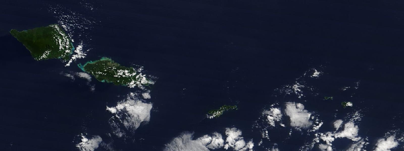
Samoa and American Samoa are neighbouring island groups, with the same people, the same language, and nearly the same sun. But Samoa sits at UTC+13 and American Samoa at UTC-11. Apia and Pago Pago are only about 125 km apart, yet they are a full 24 hours apart. Same clock time, different day. When it is Tuesday evening in Apia, it is Monday evening in Pago Pago.
 date line
On the left, the two big islands are Samoa (Savai'i and Upolu). On the right, the smaller ones are American Samoa (Tutuila and the Manu'a islands).
It was not always like this. In 2011, Samoa decided to move to the other side of the date line to be closer in time to its trading partners, Australia and New Zealand. To do it, the country simply skipped Friday, 30 December 2011. People went to bed on Thursday and woke up on Saturday. A whole day that never happened.
When time really did change little by little
My first guess was that time should change a little with every step east. It turns out the world once worked exactly like that.
Before the late 1800s, every town set its clock so that 12:00 was the moment the sun was highest in the sky. This is called local solar time. Walk a few kilometres east and your noon came a few minutes earlier.
That was fine when people moved at the speed of horses. Then came the trains. Every station had its own time, timetables became a puzzle, and trains sharing one track needed to agree on what "now" meant. In 1883 the American railroads adopted standard time zones, and in 1884 the International Meridian Conference in Washington chose Greenwich as the starting line for the world. We traded a sky full of noons for clocks that agree.
Daylight saving time: moving the clock, not the sun
The last rabbit hole was the United States and its Daylight Saving Time (DST). The idea is simple: in the warm months, move the clock forward one hour, so the evening keeps its light a little longer. The sun does not change. We only change the number we give it.
- Spring forward: on the second Sunday of March, at 2:00, clocks jump straight to 3:00. One hour of sleep disappears.
- Fall back: on the first Sunday of November, at 2:00, clocks go back to 1:00. That hour is lived twice.
Not everyone plays along. Hawaii and most of Arizona (except the Navajo Nation) stay on standard time all year, as do Puerto Rico and Guam.
What happens to GMT?
GMT, which for everyday use is the same as UTC, never moves. It is the fixed line everyone measures from. So when the US moves its clocks, its distance from GMT changes by one hour twice a year:
| US time zone | Standard time (Nov to Mar) | DST (Mar to Nov) |
|---|---|---|
| Eastern (New York) | GMT-5 | GMT-4 |
| Central (Chicago) | GMT-6 | GMT-5 |
| Mountain (Denver) | GMT-7 | GMT-6 |
| Pacific (Los Angeles) | GMT-8 | GMT-7 |
And here is a small trap. The UK and Europe also change their clocks, but on different weekends: the last Sunday of March and the last Sunday of October. So for a few weeks each spring and autumn, New York and London are only 4 hours apart instead of the usual 5. If you have ever joined a meeting an hour early or an hour late in March, this is probably why.
What I keep thinking about
Right now, as you read this, somewhere a day is ending. Somewhere, only a few kilometres away, the same day is still young. Midnight is not one moment for the whole world. It is a wave that travels around the Earth every 24 hours, and the date line is just the place where we agreed to let the wave start again.
Time feels like physics. Much of it is actually an agreement between people.
References
- International Date Line, Wikipedia
- Diomede Islands, Wikipedia
- Time in Samoa, Wikipedia
- Time zone, Wikipedia
- Time in China, Wikipedia
- International Meridian Conference, Wikipedia
- Daylight Saving Time, NIST
- Daylight saving time in the United States, Wikipedia
- When do the clocks change?, GOV.UK
- Images from Wikimedia Commons and NASA Worldview